
Here are the various maps that are used for locating a burial site within
Evergreen Cemetery and Memorial Gardens. More details follow this list.
|
If you do not yet know a person's burial location, you can use our online Directory of the Dead to look up a name. The Directory is a combined listing for burials in both the historical Evergreen Cemetery and the newer Memorial Gardens Cemetery.
The names are sorted alphabetically in the Grouped By Surname listing, and sorted by burial location (block and lot) in the Grouped By Block listing. Once you find the name, you can click on the highlighted Lot number to see who else is buried in that lot and in nearby lots.
You will need the Block identifier, Lot identifier, and burial site grave number or plot description to locate the burial site using our maps.
(This section is for the main Evergreen Cemetery in the City of Brainerd. For Memorial Gardens just north of Brainerd, see the next section.)
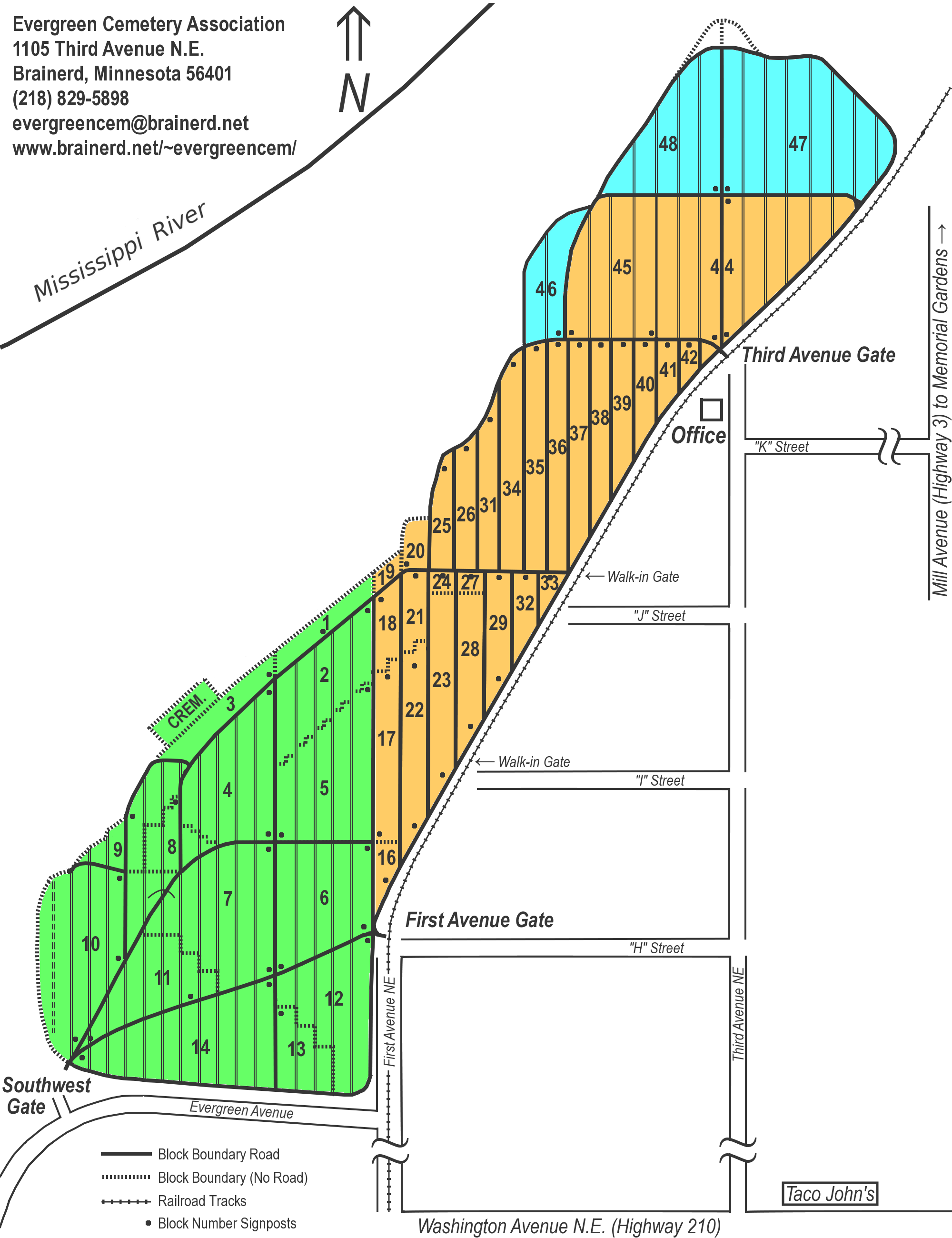
 Evergreen Cemetery burial site locations use a Block / Lot / Grave hierarchy.
There are 48 blocks, each of which is subdivided into lots (the number of
which varies from block to block).
The Cremation Section located in Evergreen has its own set of
much smaller blocks and lots.
Evergreen Cemetery burial site locations use a Block / Lot / Grave hierarchy.
There are 48 blocks, each of which is subdivided into lots (the number of
which varies from block to block).
The Cremation Section located in Evergreen has its own set of
much smaller blocks and lots.
To locate a burial site, you need to find its block on the Evergreen Cemetery Block Map (first map in the above list). To find the lot within the block, you need to find the block on the plat map for the specific “Addition” (also in the above list). The reduced-size Block Map on this page is color-coded to show the location of the Additions (green - 1st, orange - 2nd, blue - 3rd). There is also a full-sized version of the color-coded Block Map.
Not every lot is a full lot with the standard number of gravesites. Because of the angled roads, and some previously platted roads that were re-platted for additional gravesites, some lots have odd shapes and have fewer gravesites. These are referred to as “fractional lots”. Some fractional lots are so small that they were not assigned numbers and are instead referred to with a direction from a numbered lot. Examples would be “Frac. North Of” or “Frac. East Of”.
Furthermore, some lots bordering the bluff on the west side of the cemetery were laid out on paper without regard to topography. When the physical platting commenced, some lots were left unplatted because they ended up being over the side of the bluff. This is especially true in the 1st Addition.
Each full-sized lot can be further subdivided into a 4x2 configuration of 8 gravesites, each grave being 5 feet wide and 10 feet front-to-back. However, in the 1st Addition (the “Historical” section of the cemetery), the lots are only 8 feet front-to-back, and could alternatively (at the discretion of the lot owner) be subdivided into a 5x2 configuration of 10 gravesites, each grave being 4 feet wide and 8 feet front-to-back.
The lots are oriented North/South - NWC = North West Corner, SEC = South East Corner, etc.
| 8 plot lot (two halves or four quarters) | 10 plot lot (4 or 5 ft. grave width) | |||||||||||||||||||||||||||||
|
|
|
||||||||||||||||||||||||||||
As you can see in the above examples, some notations will have a corner and a distance. The corner (or sometimes a line) determines from which edge of the lot the distance is measured. The east or west designation in the corner determines which side of the lot the gravesite is on. So for example, "7½ ft. SWC" means the gravesite is on the west side of the lot, 7½ ft. north of the south edge.
ROW, GRAVE NOTATION: There are some half-lots, full lots, and two super-sized lots that use a row-grave matrix system. In the baby and child-only lots, rows are usually numbered eastward or westward and graves are numbered northward or southward, much like in an X-Y co-ordinate system. The adult grave super-sized lot 45 in block 9 is an exception to this rule. If the burial space has a X row, Y grave notation, please visit the office if you have trouble locating it. Or, if you want to try to figure it out yourself, you can click here to show more details.
CREMATION SECTION: In the Directory of the Dead listing, "CS-" in the block number column denotes the Cremation Section in Evergreen Cemetery and the number after the dash is the block within that section. Each Cremation Section block has ten 3'x3' "lots" (except block 30 which has only 5 and block 15 which has 15). Each lot can accommodate two urns.

Memorial Gardens (north of Brainerd on Highway 3) has 3 "Gardens", plus an area set aside for Columbaria.
The Garden of Paradise on the north side is the only area where above-ground markers and monuments are permitted. It uses the same gravesite descriptions as Evergreen cemetery (see above).
 The Garden of the Christus in the center and
the Garden of Devotion on the south side were laid out
in the classic style used by many of these "Garden" cemeteries.
They both have a matrix of blocks, each of which has A-D subblocks
which have 4 side-by-side grave spaces numbered 1-4
(as shown in the graphic to the left for block 150).
The Garden of the Christus in the center and
the Garden of Devotion on the south side were laid out
in the classic style used by many of these "Garden" cemeteries.
They both have a matrix of blocks, each of which has A-D subblocks
which have 4 side-by-side grave spaces numbered 1-4
(as shown in the graphic to the left for block 150).
Since the Garden of the Christus is laid out as a circle, blocks around the perimeter may be missing some of the A-D subblocks. The adjacent Garden of Devotion has a curved northern boundary, so blocks on that side are also affected.
In the Directory of the Dead, the block column has the Garden name, the
lot column has the combined block-subblock value (e.g. 12-D, or 150-A),
and the plot column has the grave space number (1-4).
The Columbaria section is to the east of the Gardens. Each Columbaria unit has a number, with side A facing west and side B facing east. Each side uses a row-niche matrix with row 1 at the top and niche 1 on the left. So in the Directory of the Dead, the Block has "Columbaria", the Lot has the unit number and side, such as 1-A, and the plot has the location on that side, such as "row 2, niche 6".
The Babyland section is in the middle of the south side of the Garden of Devotion.
![]()
| Copyright © Evergreen Cemetery Association | Directory of the Dead | Contact Us | Last Updated: |